Above what
used to be called the Bunter Beds (now the Cannock Chase Formation), lie the
Lower Keuper sandstones consisting of fine grained, red-buff sandstones widely
used as building stone in mid Staffordshire. They now form part of the Sherwood
Sandstone Group in the modern geological terminology. These sandstones form
the major part of Tixall with marl to the east and the Bunter Beds to the
south and west up to the Hopton fault which runs north/ south on the eastern
edge of Stafford.
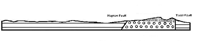 This west-east section drawn just
north of Stafford and Tixall village shows the Mercia Mudstone or Keuper Marl
to the west and far east, with the Bromsgrove sandstone or Lower Keuper, overlying
the Cannock Chase Formation or Bunter Pebble beds in the zone between the
Hopton and Tixall Faults.
This west-east section drawn just
north of Stafford and Tixall village shows the Mercia Mudstone or Keuper Marl
to the west and far east, with the Bromsgrove sandstone or Lower Keuper, overlying
the Cannock Chase Formation or Bunter Pebble beds in the zone between the
Hopton and Tixall Faults.
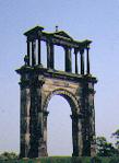
Tixall stone
was used in the building of the 1555 and 1780 Halls at Tixall; for Tixall
Gatehouse c1580; for parts of Greenbridge in 1629-30; for the cupola of St
Philips Church, now Birmingham Cathedral in 1711-1715; and for Hadrians Arch
at Shugborough in 1761-7.
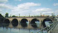 The opening of the
Staffordshire & Worcestershire Canal in 1772 enabled stone to be transported
further afield from the quay by Tixall Lock. Hence in 1781 it was used for
the Battlements and Balustrades of John Gwyn's new bridge over the Severn
at Worcester. It was also widely used for local buildings in Tixall and Stafford.
The opening of the
Staffordshire & Worcestershire Canal in 1772 enabled stone to be transported
further afield from the quay by Tixall Lock. Hence in 1781 it was used for
the Battlements and Balustrades of John Gwyn's new bridge over the Severn
at Worcester. It was also widely used for local buildings in Tixall and Stafford.
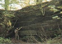
According to White
in 1834 " A large quarry of excellent freestone on this estate, supplies great
quantities of stone for building locks and bridges, for which it is particularly
well adapted, having the property of resisting the action of water. " In
1839 the stone was assessed for possible use in rebuilding the Houses of
Parliament and was described as having fine quartzose grains with a cal-careo-argillo-siliceous
cement, and plates of mica. It is a light grey sandstone and was available
in large blocks.
In the mid 19th century
Tixall Quarries were worked in conjunction with the quarries at Weston as
"Salt Quarries" for Lord Shrewsbury. The quarries finally closed at the beginning
of the 20th century.
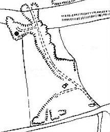
Three stone quarries are
shown on the 1833 Estate map of Tixall: at Billy's Hill; in Tixall
Park now known as Roundwood Quarry; and at Tixall Lodge. There is no public
admittance to any of the quarries.
The 1880 OS Map shows
a crane ., and a small building in the Billy's
Hill Quarry.